| This site was founded by the late John Skakel. Contact us HERE
Cemeteries Office Staff have asked that users NOT contact them with questions directly. Some History of The Howard's Bridge Cemetery
With Thanks to James Arnold, and Gordon Dickson
Note that the "Unknown Cemetery near Kent Bridge" MIGHT be what was known as the Howard's Bridge Cemetery. See Link
We have received information that there could indeed have been a cemetery at Howard's Bridge. But what... was Howard's Bridge? After a great deal of research over a lot of months, one of our researchers (Gordon Dickson) has found some information on it. There is some indication that a hundred years and more back, there was more than one definition of a bridge. There were certainly bridges as we know them today. There were also many "Fjords" or "Fords" along the river where a high vehicle or a walker might be able to cross at low water levels. Some of these MIGHT have been termed a bridge at one point in language similar to a "Land Bridge". However, our researchers have found evidence that Howard's Bridge MIGHT indeed have been a wooden bridge. These certainly did exist along the old river, at different points from it's source to it's mouth as times passed.
They have found evidence of a small "Town" of some sort at what was I believe the South East side of the bridge. And there was thought to possibly be a cemetery called Howard's Bridge Cemetery. But where was that cemetery? At this point we do not know. But finally a map has emerged showing Howard's Bridge in the 1850's time period. We hope to be able to find more on this subject as time passes.
Further information from James Arnold mentions some information on the original Arnold's Mill. Note the position of Arnold's Mill on the map. It is shown in a gear like icon on the drawing. As would generally be the case, the mill was built on a spot where sufficient water was available to run it. However, this was not the same spot that it was easy to cross the river. Mr Arnold built the mill at a spot where he could have a good water supply to run his mill but also not have to travel too far to get to a location to cross the river. At, of course, Howard's Bridge.
Have a look at the map below... (Note the positions of Chatham, Louisville, Smith's (now known as Kent Bridge) and Thamesville on the map.)
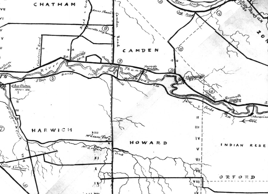
Map showing Howard Bridge around 1850. |
|